Budget Travel Korea | Seoul | Hiking Bukhansan Mountain
 |
| Embracing the view of Seoul city from Baegundae Peak |
Bukhansan literally means the 'big mountain in the north'. It has many peaks so I presume the name Bukhansan represents a very wide mountain range located north of Seoul city.
Of all the peaks, we tackled Baegundae; the tallest one standing at 836.5m above sea level. Not so high indeed, I mean even Gunung Datuk in Rembau in my state is slightly higher but being a non-hiker and all, some trails were gruesome enough for me ha ha .. (Just because I'm a guide cum operator @ Gua Batu Maloi that doesn't mean I love hiking guys). I mean, I'm more of a water sports kinda a gal, so i rarely go hiking :P. However, I thought this hiking trip was a must-do somehow ;)
There are a number of routes to the top but of course we had to take the longer one to avoid steep trails ha ha - we were not in a rush anyways.
We, my sister and I started the hike kinda late coz we left Itaewon around 10am++ and arrived at Gupabal station (line 3, orange) some 30 minutes later where we had to line up for the bus to Bukhansan National Park (exit 1).
Arriving at this station, you can already tell that you are at the right place as there were many people especially the ahjussis and ahjummas draped in top-to-toe hiking gear complete with a nifty hiking bag and a pair of hiking sticks (actually you can already see them on the orange metro too haha).
Do not let their get up intimidate you lol, or make you feel so underdressed - most often than not, foreign hikers would only be in simple outdoor attires and a pair of sneakers; you should be just fine ^^. There were also stalls selling hiking items just outside the exit in case you left anything at home - how convenient ;)
Anyway, we were grateful of these prominent local hiker crowds because their presence indicate that you are in the right place and you will always know who to ask for direction in case you lose your way haha. Plus, we went there unguided, so we were really looking forward for their company for this whole journey. That's why we purposely scheduled this trip on a Saturday ;)
The line for the bus outside exit 1 of Gupabal station was kinda long, but we only waited for a while to get on the bus as there were many buses - we took bus number 704 and got down at the Bukhansan National Park entrance stop - if you don't speak Korean don't worry, coz they also announce the stops in English. Else, just follow the hiking crowd and you'll be fine ;)

The walk from the bus stop was about 400m to the Ranger park station at the entrance and you will pass by many shops including branded stores selling hiking gear; from The North Face to The Red Face you name it =D.
We bought a map at the ranger station for 1,000KRW, asked them for an easy route to the top and then we were already on our way..
Passed through a city-wall gate (not sure of the name);

Passed through a city-wall gate (not sure of the name);

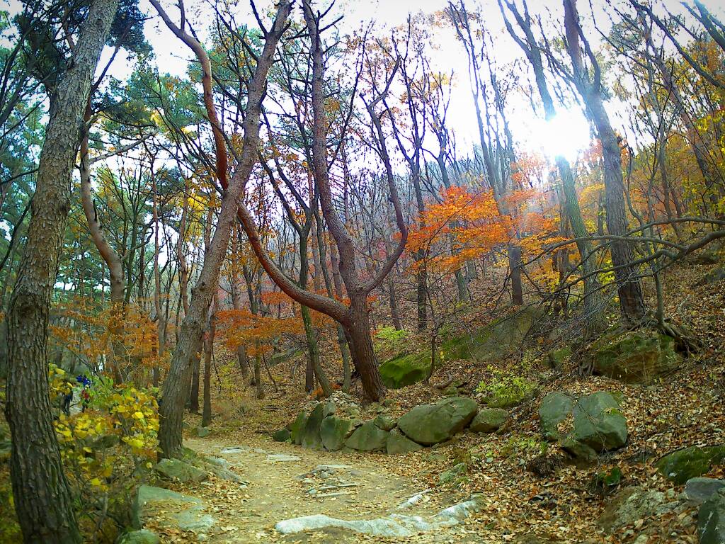
 |
| Took the stairs up on the side of the gate, and we got this view at the roof |
This was in Autumn 2016; so the colors of the falling leaves were just mesmerizing.


After about 40 minutes into the hike we found a new hiking buddy Mr. Baek - we later became each other's photographer lol.


We hiked together until we reached a shelter where we then stopped by for a quick lunch (I only had the appetite for Loacke chocolate wafers at this point).
After lunch, we parted ways; it turned out that Mr. Baek has gone to Baegundae before and was going to a different peak this time around.


After about 40 minutes into the hike we found a new hiking buddy Mr. Baek - we later became each other's photographer lol.


 |
| We had a break on a bench outside the shelter, everybody else was eating inside including Mr. Baek |
 |
| Parting ways Mr. Baek |
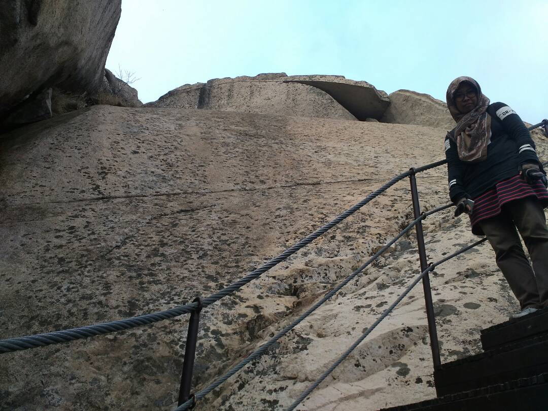
The trails after the shelter were particularly the most interesting and the views breathtaking;


We passed by a city wall, had to hike on rocky edges and also had to hold on for dear life on iron handrails built at tricky, slippery and steep slopes. There were also many staircases built where necessary so I would say a lot of the hard hiking parts have been made easy here lol. You just have to endure walking up the long staircases tho ha ha.

 |
| See that boulder on top of that mountain? That's Baegundae - to think that you are already close to the peak but you weren't lol. Another 1km+ from here |
About 300m to the top, we stopped again and this time to have some real lunch - seaweed, instant rice that we bought and heated at a convenient store near Gupabal station and chilli fried anchovies from home.. ahhhhhhh how very comforting :D.

The time was about 4pm so it was a very late lunch and many people were already descending.

 |
| Lunch with a view |
The time was about 4pm so it was a very late lunch and many people were already descending.

After lunch, we continued the hike again to the top. The closer we were to the top, the scarier the trails were as it were 100% rocky and you need to hold on to the hand rails and climb steep stairs all the way -_-


I did think that it was lucky for us to arrive this late to the top because I can't imagine having to go through this last climb with a big crowd! I mean, people can literally fall down here! Plus, we get to enjoy the almost-sunset ambiance on the mountain and enjoy the breeze up there with all the space that we share with the few other late climbers like us ha ha.
 |
| About 200m to the top |

I did think that it was lucky for us to arrive this late to the top because I can't imagine having to go through this last climb with a big crowd! I mean, people can literally fall down here! Plus, we get to enjoy the almost-sunset ambiance on the mountain and enjoy the breeze up there with all the space that we share with the few other late climbers like us ha ha.
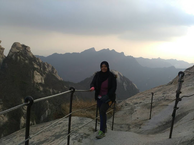

Check out the very top of Baegundae, it's a very tiny area; less than 10 people at a time can enjoy the view from here and take photos. I can't imagine doing that with the crowd.
 |
| At the very top of Baegundae |
 |
| This area is just below the top peak |
When we started our descend, it was about 5pm; the sun sets around 530pm then coz it was autumn so we were worried that it would be too dark to get down.


But it was autumn, the leaves have mostly fallen so even though it was quite late, we could still see the ground for a good 1 hour because no foliage was blocking the sunlight lol.


The thing is, we are so used to our all-year-long thick Malaysian rainforest foliage that we forget the situation is so different when hiking in a 4-climate country =D


But I did feel that the forest then looked like one of the scenes in the Blairwitch Project thriller movie ha ha..
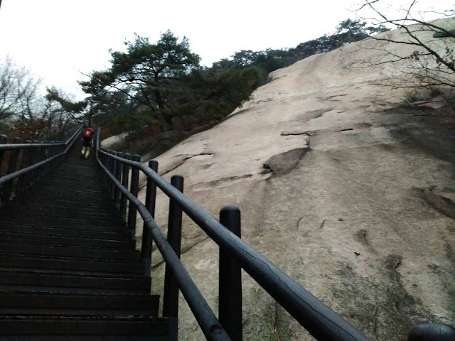
We didn't go down the same route; basically we came up from the west side of the mountain range via the Bukhansanseong route and descended to the east side via a shorter trail to Bukhansan Park Ui Ranger Station. By shorter it means that the trail is continuously steep, no easy slope -_- Checkout this never-ending flight of stairs; it looks like it could go on forever ha ha

It was already dark when we were half way down but we were somewhat at ease when we bumped into some hikers still going up the mountain at that hour, maybe they wanted to camp out there for the night.
This part of the hike we were not too sure of; however, at the bottom there was a building maybe a temple or Information Centre and a bus .. waiting for passengers. We got on that bus and turns out it's a feeder bus that takes us to a nearby neighborhood bus station - my guess, it's the Ui neighborhood, so we just asked the driver of the bus there which bus (Bus No. 1) would take us to the nearest metro station and hopped on. We then got down at Suyu station, Line 4 the light blue line .. phewwww. As long as you can get to a metro station you'll be fine ha ha .. and the whole of Seoul is well-connected to the metro lines so no worries there ;)
 |
| Descending from the very top of Baegundae |


But it was autumn, the leaves have mostly fallen so even though it was quite late, we could still see the ground for a good 1 hour because no foliage was blocking the sunlight lol.


But I did feel that the forest then looked like one of the scenes in the Blairwitch Project thriller movie ha ha..
We didn't go down the same route; basically we came up from the west side of the mountain range via the Bukhansanseong route and descended to the east side via a shorter trail to Bukhansan Park Ui Ranger Station. By shorter it means that the trail is continuously steep, no easy slope -_- Checkout this never-ending flight of stairs; it looks like it could go on forever ha ha

It was already dark when we were half way down but we were somewhat at ease when we bumped into some hikers still going up the mountain at that hour, maybe they wanted to camp out there for the night.
This part of the hike we were not too sure of; however, at the bottom there was a building maybe a temple or Information Centre and a bus .. waiting for passengers. We got on that bus and turns out it's a feeder bus that takes us to a nearby neighborhood bus station - my guess, it's the Ui neighborhood, so we just asked the driver of the bus there which bus (Bus No. 1) would take us to the nearest metro station and hopped on. We then got down at Suyu station, Line 4 the light blue line .. phewwww. As long as you can get to a metro station you'll be fine ha ha .. and the whole of Seoul is well-connected to the metro lines so no worries there ;)
In total, we spent about 7 hours to hike up and down Baegundae peak and from my experience here and a short hike that I did on one of Seoraksan trails back in Summer 2016, I have come to a conclusion that hiking in Korea is relatively less tedious than in a Malaysian (or any tropical) rainforest because of the landscape condition - Malaysian forests are mossy, muddy, slippery and the trails filled with blood-sucking leeches! Hiking in Korea is a lot simpler and cleaner lol .. u don't get dirty and just need to focus on climbing up and very much less worries on other obstacles.
Getting here:
Get down at Gupabal Station (Line 3, orange) exit 1. Make a U-turn as you walk up the staircase /escalator at the exit. You shall see a bus stop where many hikers will be lining up. Take bus number 704 to get down at Bukhansan National Park entrance.
.
When you get down at Bukhansan Park stop, walk a little towards the nearest junction where you will see the park entrance. Just walk straight from here or follow the crowd ;)
Tips: You may want to bring along a pair of gloves as the iron handrails that you need to hold as you near top will leave your hands dirty from the rust.


Comments
Post a Comment